
Walks in and around Stocksbridge
Situated roughly 10 miles from Sheffield and just over 4 miles from Penistone, Stocksbridge sits in a valley on the east edge of the Peak District. Since the 18th century it's been closely linked with the steel industry but its history can be traced back considerably further. The Stone and Steel project, www.stonetosteel.org.uk celebrates 10,000 years of history in the region and has also devised a series of informative and interesting heritage walks.
The Stockbridge Walker are Welcome website, www.stocksbridge-walkers.org.uk,is the source of the first walks on this page. Many more are available on their excellent website; the selection here is just a sample of what's available. Many thanks to the group for allowing us to reproduce the information here.
The second batch of walks are adapted from the more heritage-focused Stone to Steel website.
Stocksbridge Walks
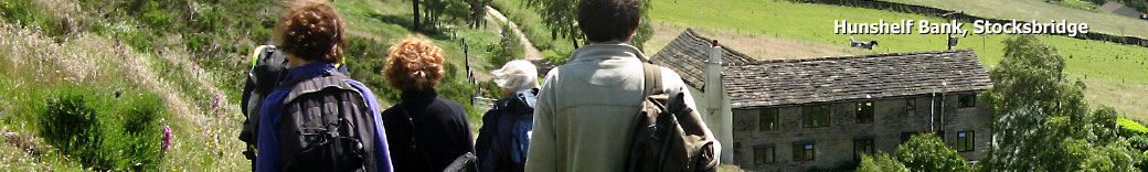
Stocksbridge Circuit
Source: Stockbridge Walkers are Welcome.
Length - 13.0 miles.
A long walk on the high ground surrounding Stocksbridge and Deepcar. Starting in Bolsterstone the route takes in Wharncliffe Crags, part of the Trans Pennine Trail, Hunshelf Bank, Undebank Reservoir, Wind Hill and Whitwell Moor. The route follows the high ground at around 1000ft but drops down to cross rivers on three occasions.
Grade: a long walk. Well defined paths. Some rough ground and stiles.
Start: Bolsterstone Village.
Parking: Bolsterstone Village.
Public transport: bus to Bolsterstone
Refreshments - Castle Inn, Bolsterstone, Underbank Outdoor Activity Centre (seasonal).
Public Toilets - In Bolsterstone
For detailed information and a downloadable, illustrated booklet (from which the above photo is taken) and map, please visit www.stocksbridge-walkers.org.uk/Walks/StocksbridgeCircuit.html
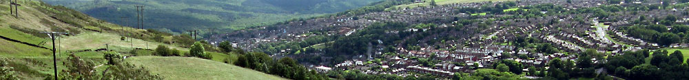
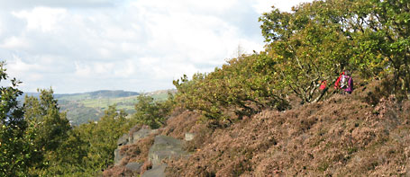
Whitwell Moor from Stocksbridge Leisure Centre
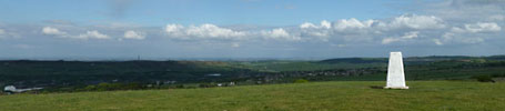
Source: Stockbridge Walkers are Welcome.
Length - 3.0 miles.
The route climbs steadily from Stocksbridge Leisure Centre, past farms and on to moorland before reaching the trig point. The route continues into quiet woodland which contains ancient earthworks and the remains of mill stone production. The walk returns to the leisure centre by a trackway with an old guidestoop.
Grade: well-defined paths. Can get muddy in places in wet weather. Some stiles and rough ground.
Start: Stocksbridge Leisure Centre, Moorland Drive, Stocksbridge, Sheffield S36 1EG.
Parking: Stocksbridge Leisure Centre.
Public transport: 23 (from Penistone), 57 and 201 Bus routes, Stocksbridge Leisure Centre.
Refreshments - Stocksbridge Leisure Centre
For detailed information and a downloadable, illustrated booklet (from which the above photo is taken) with map, please visit www.stocksbridge-walkers.org.uk/Walks/WhitwellMoor.html
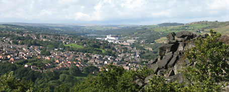
Stocksbridge to Isle of Skye Quarry and Tin Mill ponds

Source: Stockbridge Walkers are Welcome.
Length - 4.5 miles.
A walk from Stocksbridge town centre up Hunshelf bank to the disused Isle of Skye Quarry which is being developed into a nature area. The route then crosses fields and passes through mature woods as it drops down to the River Don and the Tin Mill ponds. The route returns to Stocksbridge Town Hall by Ellen Cliff and the Ford Lane path through the demolished steel works.
Grade: well marked paths, stone stiles, some rough ground, can be muddy in wet weather.
Start: Stocksbridge Town Hall, Manchester Road, Stocksbridge.
Parking: Lidl Car Park, public section at at the end furthest from the car park entrance.
Public transport: 57 and SL; 23 (from Penistone)
Refreshments: Various cafes and shops in the town centre.
Public toilets: coin operated unit opposite the Town Hall.
For full route information and illustrated PDF with map, please visit www.stocksbridge-walkers.org.uk/Walks/Skye.html
Photo: Stocksbridge Walkers.
A walk around Wharncliffe Woods from Deepcar
Source: Stocksbridge Walkers are Welcome.
Length - 2.3 or 2.7miles
Wharncliffe woods and Wharncliffe crags cover an area of several square miles. There is plenty of wildlife to watch out for, including tree pipits, nightjars, newts, and dragonflies. There are a number of forest tracks and paths that crisscross the woods. Most of the tracks and paths are not marked on any maps. Once you are familiar with the overall layout of the woods it is good to wander off up paths and see where they take you.
There is a choice of a shorter or longer version of this walk. Both walks starts by following the River Don and then climbing up through the woods. The path then emerges at the high point of the crags. Views across the Don valley and over Deepcar, past Stocksbridge to The Pennines and the Woodhead Pass in the far distance. Returning through the woods, past a large pond to the starting point.
Grade: total ascent 400 ft. Uneven surface. Muddy in wet weather. Exposed cliff edge.
Start: Station Road, Deepcar. Just beyond the Lowood Club.
Parking: Station Road
Public transport: Bus to Carr Road, Manchester Road.
Refreshments: none on the route.
Public toilets: none on the route.
For full route information and illustrated PDF with map, please visit http://www.stocksbridge-walkers.org.uk/Walks/WharncliffeWoods.html
Photo: Stocksbridge Walkers.
Stocksbridge Heritage Trail
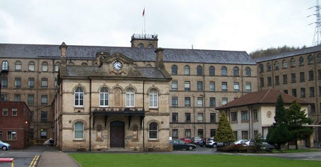
Source: Stone to Steel
Length - 15½ km / 9½ miles
Stone to Steel is a project celebrating 10,000 years of human history in the Upper Don Valley, covering an area of approximately ten square miles around Stocksbridge.
It encompasses the towns and villages of Stocksbridge, Midhopestones, Wharncliffe Side, Oughtibridge, Bolsterstone, Deepcar and Grenoside.
There are 6 walks available to download on the Stone to Steel website, www.stonetosteel.org.uk.
This one follows the development of the town of Stocksbridge itself. Sights include mine workings, Stocksbridge steel works, the Steel Valley Walk and Underbank reservoir.
For full route information and illustrated PDF with map, please visit www.stonetosteel.org.uk/heritage_trails.php.
Photo: Samuel Fox iron and steel works - Wikicommons.
Parsonage Farm and Townend Common
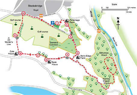
Source: Stone to Steel
Length - 5½ km / 3½ miles
Another Stone to Steel walk: Parsonage Farm and the Ewden Valley on an easy going trail with some steep climbs.
Sights include Parsonage Farm , Bitholmes Wood, Walder's Low, Ewden Valley.
Parsonage Farm was established near Townend Common 700 years ago. Owned by a local church it was the Parson's home.
Bitholmes Wood is ancient woodland dating to at least 1600 AD. As early as the Middle Ages it was used for hunting game, more recently for mining and quarrying.
Walder’s Low, is a mound of earth and stone believed to date from the Late Neolithic or Early Bronze Age. It may have been reused as a burial chamber for Walder, a Saxon chief. Being approximately 5000 years old, this monument is about the same age as Stonehenge.
For full route information and illustrated PDF with map, please visit www.stonetosteel.org.uk/heritage_trails.php.
Map and text taken from the leaflet above.
Other websites
Both the Stocksbridge Walkers are Welcome and Stone to Steel websites feature more walks and are both worth investigating. The Bradfield Walkers are Welcome website is also worth visiting if you're interested in the region - the parishes of Bradfield and Stockbridge are adjacent and some of the walks span the two.
Reservoirs in the area are maintained by Yorkshire Water - thier site features several walks and activities in the area.
Wheely Easy Walks
Bradfield Walkers are Welcome group were awarded a grant in August 2011 from the Sheffield City Council 50+ Small Sparks for Older People fund to investigate routes in the Bradfield area suitable for mobility-impaired walkers, especially users of wheelchairs and mobility scooters.
As a result of feedback from users and visits to the area to assess routes, a leaflet has been produced to allow those wishing to enjoy Bradfield’s countryside to judge the suitability of routes for themselves taking into account their particular circumstances and local conditions.
You can download the leaflet from the Bradfield Walkers are Welcome home page.
Public Transport
You can plan transport to the start points with the Travel South Yorkshire Journey Planner which includes information for both trains and buses.