
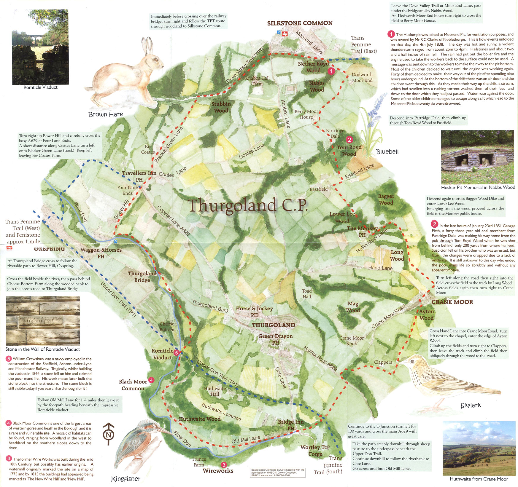
Thurgoland Boundary Walk
Click the icons or route (the blue line) on the map for more information.
You can also view a larger, printable version of the Thurgoland Boundary Walk map (opens in new window). Photos taken in the area are also available on that page - click the drop-down menu (starts with "traffic") on the right of the map for more options.
Please note that the route is for guidance only. If you spot any errors please notify us and we will make corrections as soon as possible.
The Route
The Thurgoland Boundary Walk is a 9 mile circular route offering a unique chance to experience the diverse nature of part of the Barnsley Borough.
A mixture of tranquil open fields and dense woodland are interlinked with disused railways and winding country lanes to provide a varied and interesting route around the boundary of the South Yorkshire village of Thurgoland.
The route passes alongside the other Villages of Silkstone Common, Oxspring and Crane Moor. There's also the spectacular view of the River Don valley floor to the south where the meandering river is visible at certain locations.
The walk is mainly on public footpaths available for walkers only. The stretch along the Trans Pennine Trail is accessible to cyclists, horsriders, pushchair and wheelchair users.
The paths are generally good surfaces but some areas may be wet after rain or in winter (walking boots are recommended).
The route is hilly but has a good mixture of hard surfaces, pasture, woodland and short sections of road (take care when crossing the busy main roads).
- Taken from the official leaflet, an adaptation of which can be downloaded from the box on the right.
Details and information
Distance:
8.73 miles (as calculated by the Google map)
Places on the route or nearby:
Thurgoland, Oxspring, Crane Moor, Wortley Top Forge, Trans Pennine Trail
Facilities: There are a number of Public Houses on or near the route. Those listed below are where the proprietor has agreed to let you park in their car parks. If you are part of a larger walking group please contact them prior to your walk.
- Bridge Inn, Forge Lane, Telephone 0114 2882016
- The Monkey, Hollin Moor Lane, Telephone 0114 2883594
- Green Dragon, Halifax Road, Telephone 0114 2882297
- Horse and Jockey, Roper Lane, Telephone 0114 2882354
- Waggon & Horses, Sheffield Road, Telephone 01226 763259
- Travellers Inn, Maggot Lane, Telephone 01226 762518
Links and other info:
Click here for a PDF version of the leaflet (1.2MB).
Click here for a high-resolution version of the map included in the above leaflet (scanned fom the leaflet - so not perfect!).
For more information about the Trans Pennine Trail visit the official website, www.transpenninetrail.org.uk